
ATLANTA — The Georgia General Assembly has approved a redrawn map of Newton County commission and school board districts that expands the land area of two Republican-dominated districts.
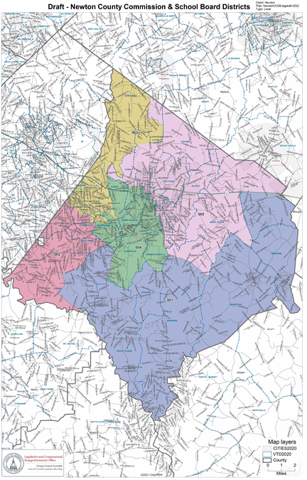
The map also keeps all districts mostly equal in population and with the same racial majorities as before, with districts 2, 3 and 4 majority Black and districts 1 and 5 majority white.
The Georgia House on Monday, Feb. 14, gave final approval to the Senate-approved version of the bills that legally define the new county commission and school board district lines that correspond to the map.
Among the changes are the city of Oxford moving into Republican-held District 5 and Springhill moving into Democrat-dominated District 4.
Newton County Board of Commissioners voted in January against agreeing to a district map drawn by the state Legislative and Congressional Reapportionment Office
The action left it up to local legislators in the Republican-controlled General Assembly who approved a different version of a map that shifts district lines to conform to Newton County population changes found in the 2020 federal census.
All but one district in the final version are within 1% of the required "ideal" district population of 22,497 — ranging from 0.62% under the "ideal" count to 0.13% over it.
However, the map has District 2 exceeding the ideal count by 1.13%.
According to information from RedistrictingOnline.org, the U.S. Supreme Court has interpreted the constitutional requirement of equal population between districts, or the “one-person, one-vote standard," to require "general population equality between districts" but without a precise number or percentage defining constitutionality.
As a result, the Court says local districts should be “substantially equal," as opposed to congressional districts which must have “strict equality," according to the website RedistrictingOnline.org.
The Court also generally has held that any legal challenges to maps using districts with 10% or less deviation would place the burden on the challenger to provide additional evidence about why the deviation was not permitted, according to information from RedistrictingOnline.org which includes the National Conference of State Legislatures as a partner.
"The U.S. Supreme Court has declined to identify any specific percentage that would represent a violation of one-person, one vote," according to RedistrictingOnline.
"Their reasoning is that, as soon as they did, line-drawers would have every incentive to gerrymander maps as they pleased, with no restrictions as long as they stay below the stated limit. The Court has instead used the 10% deviation measure to adjust the evidentiary burdens on the parties to the lawsuit.”
Charles Bullock of the University of Georgia recently told an Athens newspaper that a county district map could only be challenged in the court system in two areas.
A population challenge could be done based on the general rule that districts have to be within plus or minus 5% of the average population; or if any changes make it more difficult for an area represented by a minority candidate to continue electing minority candidates.
However, Newton officials have said the maps the state reapportionment office produced do not appear to violate either of those areas.
Commissioners voted in January not to approve a proposed map drawn by the legislative reapportionment committee.
Before the vote, county attorney Patrick Jaugstetter told commissioners they were considering a resolution that would “indicate to the local legislative delegation and to the Georgia General Assembly your approval of the map.”
He said the law does not require a unanimous Board vote for the map but the county’s legislative delegation generally “expects” full support before sending it for approval by the full General Assembly.
“I would expect — and I can’t say this with absolute certainty — that if it’s less than unanimous, your local delegation may not pursue it diligently,” Jaugstetter said.
District 17 State Sen. Brian Strickland, R-McDonough, said in January that he felt "confident that our legislative delegation will get this done without any issues” and was unsure of what map the county commission could not agree on.
The Constitution requires the General Assembly to pass an updated redistricting map every 10 years to ensure population is roughly equal in each district based on the latest federal Census count.


